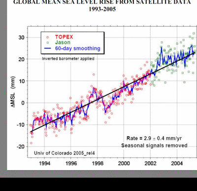
It's Deja Vu all over again, but this time the highly questionable "adjustments" are not to temperature records, but to satellite sea level altimetry data. A publication at the EPA website called SEALEVEL_FINAL.PDF, has a graph of TOPEX/JASON sea level rise circa 2005 (see notation in lower left of blink chart) on page 7. The 2005 version of the data is no longer available online, but comparing to the current version online shows:
- The drop following the 1997-1998 record El Nino essentially disappears and the remainder of the record builds upon the El Nino anomaly (see below)
- The slope over the entire periods increases from 2.9 mm to 3.1 mm/yr even though plotting the 2005-2009 data shows the slope decreased to less than half the former rate
- The data shows much less dispersion in 2010, even from the TOPEX satellite that was no longer in operation for more than 3 years prior to the 2005 graph
- Most of the low outliers are pushed up and high outliers left in for the 2010 chart
- The JASON data in 2005 prior to removing the low outliers appears to show little if any sea rise
- The near stationary trend of TOPEX sea level data from the 2 graphs below the blink graph is replaced by an increasing trend in the 2005 graph and even more so in the 2010 graph.
- The beginning sea level anomaly is about 5 mm less in the 2005 chart than the 2010 chart
The AVISO website has the following graph of the TOPEX data 1993-1998 to illustrate that the record El Nino in 1997-1998 had a significant effect on the global mean sea level:


Nils-Axel Morner reports "Over the last 40 years we record a virtually fully stable eustatic sea level" 3/26/10:
ReplyDeletehttp://sppiblog.org/news/the-birth-and-death-of-an-island-in-the-bay-of-bengal